A new website has been created with several new features including direct gps download and soon a hiker’s forum. The site was created by Scott McMillan the endurance junky. Check it out at hikealberta.com.
March 16, 2007
Bowness to Valley Ridge
Posted by 4leggedfriend under Bowness, Calgary, Valley RidgeLeave a Comment
Hike Alberta has been moved, view the new and improved post for this hikes, several others and use the other features of the site at hikealberta.com
Name: Bowness to Valley Ridge
Hike Distance: 1.9 km one-way
Time required: 1-1.5 hours return
Difficulty: Easy
Elevation Gained: 38 metres
Total Climb: 106 metres
Dog Friendly: Yes
Bikes: Permitted but not recommended (numerous stairs)
Location: For this walk you are best to park near the intersection of 48 Avenue NW and 33 Avenue NW. Walk to the North of the George Wood Learning Centre and the trail starts at Waypoint #101. The other option is to start in Valley Ridge on Valley Springs Road NW.
The total walk is 3.8 kilometres return. It is my favourite along the Bow in Calgary.
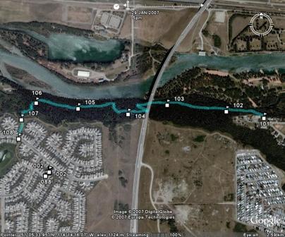
Go to Everytrail to check out the Google Earth view of this path and download the GPS track.
This walk is nice because the trail, especially the section from the Stony Trail overpass to Valley Ridge, feels like you have left town. Very beautiful and peaceful. 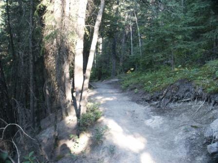
Please submit your feedback and let me know your thoughts on the hike. If you have the gps data for other hikes in Alberta please send it along with a couple pictures to hikealberta@gmail.com.
March 15, 2007
Elbow Falls
Posted by 4leggedfriend under Elbow Falls, Elbow Valley, Highway 66, KananaskisLeave a Comment
Hike Alberta has been moved, view the new and improved post for this hikes, several others and use the other features of the site at hikealberta.com
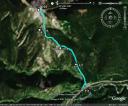
Name: Elbow Falls
Hike Distance: 1 km return
Time required: 15-30 minutes
Difficulty: Easy
Elevation Gained: 25 metres
Total Climb: 25 metres
Dog Friendly: Yes
Bikes: Permitted
Location: This trail is 19 kilometres west of the junction with highway 22 on highway 66. It is the last parking lot before the winter gate which opens May 1. Parking is in the Elbow Falls Recreation Area. The trail starts at either side of the parking lot.
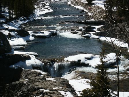
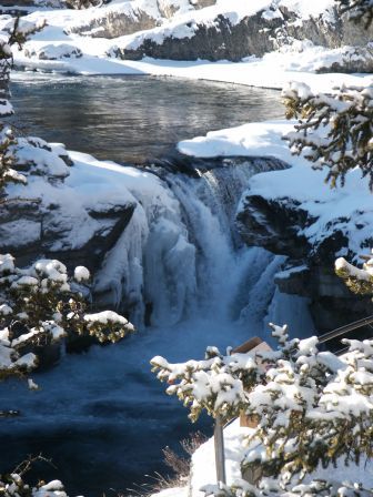
For this hike you hardly need Gps. The trail is paved and most of it is wheelchair accessible. These falls are the largest accessible falls in Kananaskis. The picnic area is extremely popular and often if you do not get there early you will be out of luck.
Here are a couple of shots of the falls. From above:
On the lower path:
If you want to see the Google Earth view of this trail or download the Gps track check out Everytrail.
Please submit your feedback and let me know your thoughts on the hike. If you have the gps data for other hikes in Alberta please send it along with a couple pictures to hikealberta@gmail.com.
March 6, 2007
Deer Ridge Trail
Posted by 4leggedfriend under Highway 68, Kananaskis, UncategorizedLeave a Comment
Hike Alberta has been moved, view the new and improved post for this hikes, several others and use the other features of the site at hikealberta.com
Name: Deer Ridge Trail
Hike Distance: 6 km return
Time required: 1.5-3 hours
Difficulty: Moderate
Elevation Gained: 220 metres
Total Climb: 383 metres
Dog Friendly: Yes
Bikes: Permitted
Horses: Permitted
Location: For this one I suggest that you load the GPS track and waypoints and tell your unit to take you to waypoint #60. The first couple of times I did this hike I missed the turnoff to the Sibbald Lake Campground Access Road. The road signs seem less than clear.
Head west on highway #1 from Calgary. Approximately 16 kilometres west of the intersection of highway #22 and highway #1 head south (left) on Sibbald Creek Trail (Highway #68). Continue on Highway #68 for 22 kilometres then turn right onto the Sibbald Lake Campground access road. You will come to an intersection. Straight ahead goes to the picnic area but turn left head 200 metres to the Sibbald Flat Trail sign in the west parking lot.

The hike starts at waypoint #60 on the Sibbald Flat Trail. At waypoint #61 is the first fork. Keep to the right and you will be on the Eagle Hill Trail. This travels for about 2.6 kilometres above Moose Pond until you reach a barb wired fence. Here, at waypoint #65 you turn left and follow a barb-wired fence for a short distance. The Deer Ridge Trail starts at this point. If you go straight instead of turning left along the fence 4.5 kilometres further along the Eagle Hill Trail is the Eagle Hill Lookout.
After a few hundred metres along the Deer Ridge Trail in a relatively open area you will reach waypoint #66. Here turn right and follow the cutline up the hill. At the top the trail turns southeast. I took this photo at waypoint #67.
At waypoint #68 there is a hitching station for horses. There is a trail to the side of the hitching post that heads to the lookout. After continuing along the ridge, there are not any other junctions until waypoint #71 where you turn left. The trail goes back near Sibbald Lake and then to the start at waypoint #61.
Download the GPS track at Motion Based.
Please submit your feedback and let me know your thoughts on the hike. If you have the gps data for other hikes in Alberta please send it along with a couple pictures to hikealberta@gmail.com.
February 28, 2007
Cox Hill
Posted by 4leggedfriend under Bragg Creek, Cox Hill, Elbow Valley, Highway 66, Jumpingpound Mountain, Kananaskis, Powderface TrailLeave a Comment
Hike Alberta has been moved, view the new and improved post for this hikes, several others and use the other features of the site at hikealberta.com
Name: Cox Hill
Hike Distance: 11.5 km return
Time required: 3.5 – 6 hours
Difficulty: Strenuous
Elevation Gained: 700 metres
Total Climb: 861 metres
Dog Friendly: Yes
Bikes: Permitted
Horses: Permitted
Location: Head west on highway #1 from Calgary. Approximately 16 kilometres west of the intersection of highway #22 and highway #1 head south (left) on Sibbald Creek Trail (Highway #68). After traveling 23 kilometres turn left onto the Powder Face Trail Road and then after 3 kilometres into the Dawson Equestrian Area. Trailhead is near entrance to the parking lot.
Here is the topographical map for this hike.
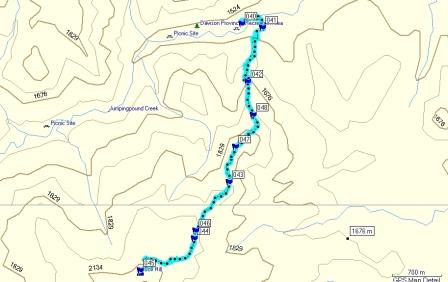
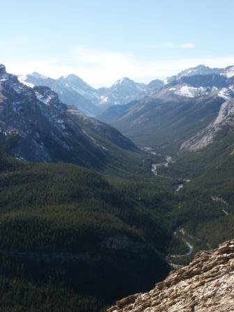
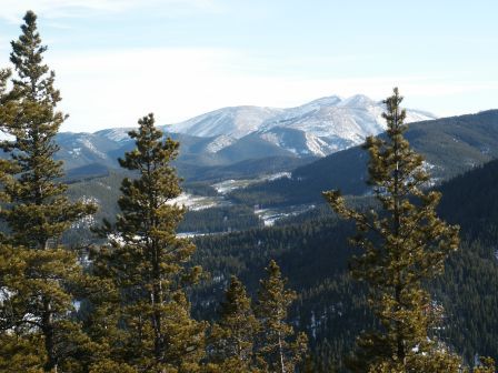
On the day I did this hike the snow was fairly deep and of the hikes I have done so far in the Kananaskis this was the most strenuous. After leaving the parking lot at waypoint #040 it is a few hundred metres to waypoint #41 which is the intersection of the Tom Snow and Cox Hill Trails. Keep to the right travel another 3 or 4 hundred metres and after this point it is almost a non-stop climb of varying degrees to the top of Cox Hill. There are a couple of points along the trail where you look out over the hills below. Once at the top, to the north west there is an impressive range of mountains which I photographed. To be honest, at this point I wished I had a telephoto lens.
This view is to the southwest and the trail to Jumping Pound Mountain would be along this range.

During the summer months it is possible to leave a vehicle further south along Powderface Trail allowing you to continue from Cox Hill along the ridge to Jumping Pound Mountain. During the winter the winter gate prohibits traveling any further south along Powderface Trail than the Dawson Recreational Area. It is approximately 5.5 kilometres from the top of Cox Hill to Jumpingpound Mountain. That would be 20 kilometres return.
Please submit your feedback and let me know your thoughts on the hike. If you have the gps data for other hikes in Alberta please send it along with a couple pictures to hikealberta@gmail.com.
February 23, 2007
Sulphur Springs Loop
Posted by 4leggedfriend under Elbow Valley, Highway 66, Kananaskis, Sulphur Springs Loop[2] Comments
Hike Alberta has been moved, view the new and improved post for this hikes, several others and use the other features of the site at hikealberta.com
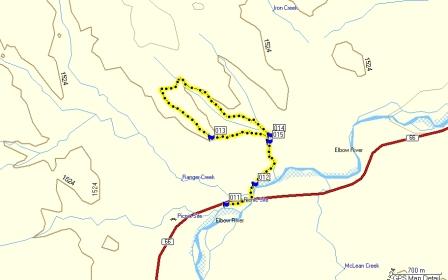
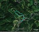
Name: Sulphur Springs Loop
Hike Distance: 12.5 km return
Time required: 2.5-4 hours
Difficulty: Moderate
Elevation Gained: 216 metres
Total Climb: 515 metres
Dog Friendly: Yes
Bikes: Permitted
Horses: Permitted
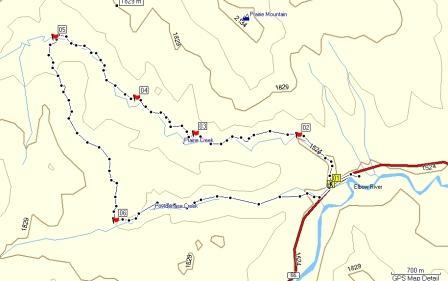
Location: This hike is starts at the Station Flats Parking area approximately 11 kilometres east of the intersection with highway 22 on highway 66.
This trail, along with the Diamond T Loop which starts at the same point, are very popular trails for mountain biking. Both are rolling trails and are very open. During the spring the meadows are full of wild flowers.
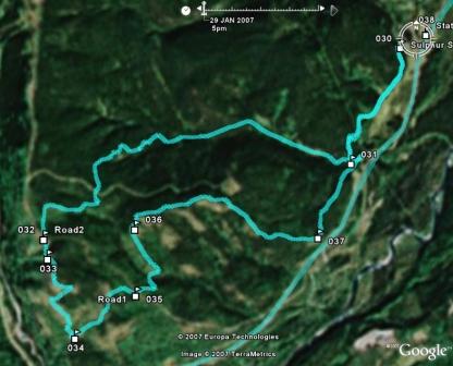
Here is the topographical view of this hike.
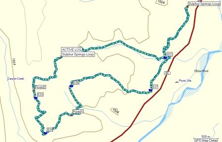
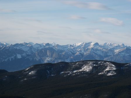
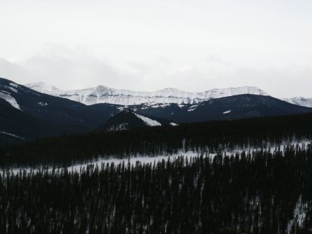
From the trailhead, keep to the left and parallel the highway for 1.3 kilometres at which point you will be at the intersection of the Elbow Valley Trail and the Sulphur Springs Trail (waypoint #031). Turn to the right and head up the Sulphur Springs Trail. You will cross the Moose Moutain Road (watch for cars) and at waypoint #033 you will be treated to this view.
At waypoint #034 is the intersections of the Sulphur Springs Trail, the Elbow Valley Trail and the River View Trail. Head to the left on the Elbow Valley Trail to return home. It is well marked as is the rest of this trail. I assume that it is because this is such a popular bike trail and it is easy to get lost if you are ripping along. To get from waypoint #031 to #033 is approximately 4.6 kilometres. From #034 back to #031 along the Elbow Valley Trail is approximately 4.4 kilometres. You will cross the Moose Mountain Road again.
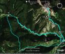
Here is the Google Earth profile for this hike. Go to Motion Based for the GPS track.
Please submit your feedback and let me know your thoughts on the hike. If you have the gps data for other hikes in Alberta please send it along with a couple pictures to hikealberta@gmail.com.
February 18, 2007
Prairie Creek
Posted by 4leggedfriend under Elbow Valley, Highway 66, Kananaskis, Prairie Creek[2] Comments
Hike Alberta has been moved, view the new and improved post for this hikes, several others and use the other features of the site at hikealberta.com
Name: Prairie Creek
Hike Distance: 6 km return
Time required: 1.5-3 hours
Difficulty: Moderate
Elevation Gained: Minimal
Dog Friendly: Yes
Bikes: Permitted
Horses: Permitted
Location: This hike, along with Prairie Mountain starts at the parking lot on highway 66 approximately 19 kilometres west of the intersection of highways 22 and 66.
The route shown is three separate legs. The first 6 kilometres is the Prairie Creek Trail. The Trail continues on but at waypoint 5 is the intersection with the Prairie Link trail. This 3 kilometre section joins up with the Powderface Creek Trail for approximately 3 kilometres. The Powderface Creek trail ends about 200 metres west of the starting point for the Prairie Creek Trail. The total distance is 12.6 kilometres. The total climb is 300 metres so overall it is a pretty flat trail.
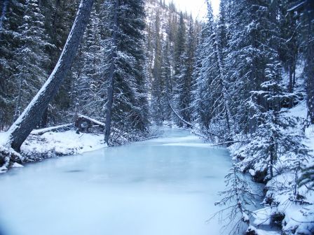
This photo was taken at the start, the creek is beautiful frozen or thawed.
This is the topographical map of this hike.
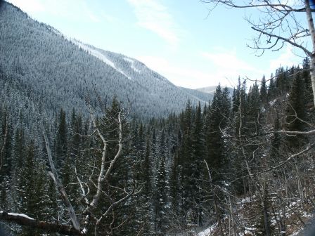
This photo was taken at waypoint 3 along the ridge above Prairie Creek.
On the day I did this hike it was slippery, like a skating rink. This is one of those trails that is cut into the side of the mountain. Anytime there is a thaw the water pools on the trail and freezes. At one point I slid off the trail for about 30 feet down onto the creek. Luckily it was frozen solid, otherwise I would have been wet. The GPS track is not available, it seems that when Garmin says that the batteries on the Etrex Legend will last up to 30 hours, greater emphasis should be put on the “up to” portion. In any event, just program in waypoints 5 and 6. Otherwise the trail is pretty easy to follow. Because of the way this trail drains I do not think I will go back until the spring. The position of these waypoints are as follows:
Waypoint #5 N50 53.125 W114 50.708
Waypoint #6 N50 51.714 W114 49.970
The Google Earth Map shows both the Prairie Creek and Prairie Mountain trail. I like this map, if you do both it allows you to have a better sense of your location and surroundings during the hike.
Please submit your feedback and let me know your thoughts on the hike. If you have the gps data for other hikes in Alberta please send it along with a couple pictures to hikealberta@gmail.com.
February 7, 2007
Prairie Mountain
Posted by 4leggedfriend under Bragg Creek, Calgary, Elbow Valley, Highway 66, Kananaskis, Prairie Mountain[2] Comments
Hike Alberta has been moved, view the new and improved post for this hikes, several others and use the other features of the site at hikealberta.com
Name: Prairie Mountain
Hike Distance: 7.6 km return
Time required: 1.5-2.5 hours
Difficulty: Moderate-Difficult
Elevation Gained: 726 metres
Dog Friendly: Yes
Bikes: Permitted
Horses: Permitted
Location: The trailhead is located on Highway 66, just south of the Elbow Falls winter gates and on the east (northeast) side of Prairie Creek.
Prairie Mountain is my favourite hike along highway 66. It is approximately 3.8 kilometres one way with a gain of altitude of 726 metres. Depending on the conditions it takes between 1.5 and 2.5 hours but this can vary greatly depending on whether your are used to steep inclines. For the most part the unmarked path is easy to follow. From the highway the incline is steep before it eases for a short period and finishes with switchbacks to the top of the mountain. The final section leads you to a summit with excellent views of the surrounding mountain region.
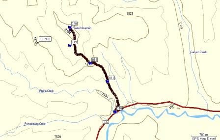
Waypoint 16 is where the trail starts at the Northeast side of the highway at the east side of the bridge. The parking lot is about 200 metres to the west of this point. There a several paths that climb the ridge above the highway to waypoint 17 but they all seem to end up at the same place where the trail continues to the top . Waypoint 19 is at the treeline and the access point to the summit. I do not think you could get to the top without going to this point.
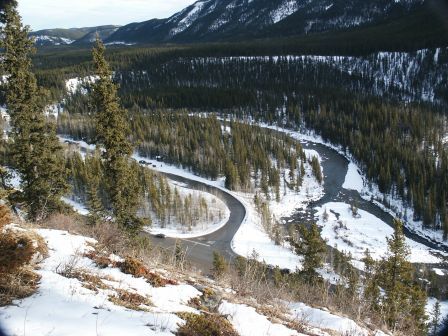
This photo is taken at waypoint 17. It is a shot with an overview of the Elbow Falls recreational area. Beautiful spot, this is a wheelchair accessible area with lots of picnic tables. A great spot to have a meal or relax after climbing prairie mountain.
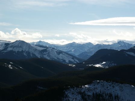
This photo was taken a waypoint 18 facing back towards highway 66.
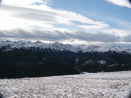
This is the view of the backside of Prairie Mountain. Well worth the effort.
Here is the Google Earth profile of this hike.
Google Earth
Motion Based
Please submit your feedback and let me know your thoughts on the hike. If you have the gps data for other hikes in Alberta please send it along with a couple pictures to hikealberta@gmail.com.
February 7, 2007
Fullerton Loop
Posted by 4leggedfriend under Bragg Creek, Calgary, Elbow Valley, Fullerton Loop, Highway 66, Kananaskis[4] Comments
Hike Alberta has been moved, view the new and improved post for this hikes, several others and use the other features of the site at hikealberta.com
Name: Fullerton Loop
Hike Distance: 7 km return
Time required: 1.5-2.5 hours
Difficulty: Easy to Moderate
Elevation Gained: 190 metres
Total Climb: 364 metres
Dog Friendly: Yes
Location: This trail is west of Bragg Creek along highway 66. The parking area is 9.7 kilometres west of the intersection of highways 22 and 66. It starts at the far east end of the parking area at Bill Allen Pond.
Bill Allen Pond just finished a major construction overhaul that is almost complete. The pond is improved and there is a great picnic area. Some of the maps indicate that the Fullerton Loop trail starts about 1.5 km along the Elbow Trail but as far as I am concerned it starts in the parking area at Bill Allen Pond. This is one of those elusive trails I have seen estimates of its length as being from 2.8 to 7.0 kilometres and several variations as to its altitude gain. According to my gps track the is 7 kilometres, the elevation gain is 190 metres and I would estimate that it will take most people between 1.5 hours and 2.5 hours to complete. Here is the topographical view of the hike.
The GPS data starts at the parking lot. If you look at the google map waypoint 11 is the parking lot, waypoint 15 is the intersection of the Fullerton Loop and the trail to West Bragg Creek. Keep to the left but it is clearly signed. At waypoint 14 is the junction there is a set of crude stairs cut into the hillside. If you go left you will do the steep section first. I suggest that you keep to the right unless the conditions are slippery. I find it easier to climb a slippery section than trying to get down it and I would only go left at the junction if you are concerned about traction. Taking the trail to the right leads to a long gradual ascent through the forest to the half-way point of the loop where you can view Moose Mountain and the group of mountains surrounding Banded Peak. The return trip skirts the edge of a steep hillside overlooking the Ranger Station and the Elbow Valley.
I took this picture at waypoint 12 about three hundred metres after walking under the highway bridge.

This picture is an example of the stunning views on the way back to the junction at waypoint 14.

Here are the Motion Based and Google Earth profiles. Click on the words “Motion Based” to download the gps track.
Please submit your feedback and let me know your thoughts on the hike. If you have the gps data for other hikes in Alberta please send it along with a couple pictures to hikealberta@gmail.com.
February 7, 2007
View from the Top of Nihani Ridge
Posted by 4leggedfriend under Calgary, Highway 66, Nihani RidgeLeave a Comment