A new website has been created with several new features including direct gps download and soon a hiker’s forum. The site was created by Scott McMillan the endurance junky. Check it out at hikealberta.com.
Uncategorized
Archived Posts from this Category
March 6, 2007
Deer Ridge Trail
Posted by 4leggedfriend under Highway 68, Kananaskis, UncategorizedLeave a Comment
Hike Alberta has been moved, view the new and improved post for this hikes, several others and use the other features of the site at hikealberta.com
Name: Deer Ridge Trail
Hike Distance: 6 km return
Time required: 1.5-3 hours
Difficulty: Moderate
Elevation Gained: 220 metres
Total Climb: 383 metres
Dog Friendly: Yes
Bikes: Permitted
Horses: Permitted
Location: For this one I suggest that you load the GPS track and waypoints and tell your unit to take you to waypoint #60. The first couple of times I did this hike I missed the turnoff to the Sibbald Lake Campground Access Road. The road signs seem less than clear.
Head west on highway #1 from Calgary. Approximately 16 kilometres west of the intersection of highway #22 and highway #1 head south (left) on Sibbald Creek Trail (Highway #68). Continue on Highway #68 for 22 kilometres then turn right onto the Sibbald Lake Campground access road. You will come to an intersection. Straight ahead goes to the picnic area but turn left head 200 metres to the Sibbald Flat Trail sign in the west parking lot.

The hike starts at waypoint #60 on the Sibbald Flat Trail. At waypoint #61 is the first fork. Keep to the right and you will be on the Eagle Hill Trail. This travels for about 2.6 kilometres above Moose Pond until you reach a barb wired fence. Here, at waypoint #65 you turn left and follow a barb-wired fence for a short distance. The Deer Ridge Trail starts at this point. If you go straight instead of turning left along the fence 4.5 kilometres further along the Eagle Hill Trail is the Eagle Hill Lookout.
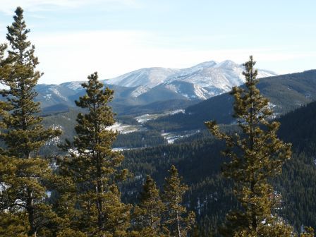
After a few hundred metres along the Deer Ridge Trail in a relatively open area you will reach waypoint #66. Here turn right and follow the cutline up the hill. At the top the trail turns southeast. I took this photo at waypoint #67.
At waypoint #68 there is a hitching station for horses. There is a trail to the side of the hitching post that heads to the lookout. After continuing along the ridge, there are not any other junctions until waypoint #71 where you turn left. The trail goes back near Sibbald Lake and then to the start at waypoint #61.
Download the GPS track at Motion Based.
Please submit your feedback and let me know your thoughts on the hike. If you have the gps data for other hikes in Alberta please send it along with a couple pictures to hikealberta@gmail.com.
