Hike Alberta has been moved, view the new and improved post for this hikes, several others and use the other features of the site at hikealberta.com
Name: Fullerton Loop
Hike Distance: 7 km return
Time required: 1.5-2.5 hours
Difficulty: Easy to Moderate
Elevation Gained: 190 metres
Total Climb: 364 metres
Dog Friendly: Yes
Location: This trail is west of Bragg Creek along highway 66. The parking area is 9.7 kilometres west of the intersection of highways 22 and 66. It starts at the far east end of the parking area at Bill Allen Pond.
Bill Allen Pond just finished a major construction overhaul that is almost complete. The pond is improved and there is a great picnic area. Some of the maps indicate that the Fullerton Loop trail starts about 1.5 km along the Elbow Trail but as far as I am concerned it starts in the parking area at Bill Allen Pond. This is one of those elusive trails I have seen estimates of its length as being from 2.8 to 7.0 kilometres and several variations as to its altitude gain. According to my gps track the is 7 kilometres, the elevation gain is 190 metres and I would estimate that it will take most people between 1.5 hours and 2.5 hours to complete. Here is the topographical view of the hike.
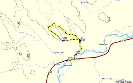
The GPS data starts at the parking lot. If you look at the google map waypoint 11 is the parking lot, waypoint 15 is the intersection of the Fullerton Loop and the trail to West Bragg Creek. Keep to the left but it is clearly signed. At waypoint 14 is the junction there is a set of crude stairs cut into the hillside. If you go left you will do the steep section first. I suggest that you keep to the right unless the conditions are slippery. I find it easier to climb a slippery section than trying to get down it and I would only go left at the junction if you are concerned about traction. Taking the trail to the right leads to a long gradual ascent through the forest to the half-way point of the loop where you can view Moose Mountain and the group of mountains surrounding Banded Peak. The return trip skirts the edge of a steep hillside overlooking the Ranger Station and the Elbow Valley.
I took this picture at waypoint 12 about three hundred metres after walking under the highway bridge.

This picture is an example of the stunning views on the way back to the junction at waypoint 14.

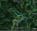
Here are the Motion Based and Google Earth profiles. Click on the words “Motion Based” to download the gps track.
Please submit your feedback and let me know your thoughts on the hike. If you have the gps data for other hikes in Alberta please send it along with a couple pictures to hikealberta@gmail.com.

October 20, 2009 at 3:32 am
Thanks for posting this, I wish I had you as a hiking buddy. We moved to Bragg Creek two years ago and I have been exploring the place with my dogs ever since. I will be doing this hike tomorrow, but have done most of the other loops in Kananaskis park… I still do not have a GPS but am hoping I get one from the hubby for Christmas. My iPhone google GPS is garbage to be honest.
You did such a nicely detailed write up Did the other loop father up the trail and passed the entry to the Fullerton loop on my way in, and can’t wait to brave to mud and ice to enjoy it in the morning.
Cheers Diana
November 12, 2011 at 12:33 am
hammock camping blog…
[…]Fullerton Loop « Hike Alberta[…]…
February 8, 2012 at 6:27 am
seo danışmanı…
[…]Fullerton Loop « Hike Alberta[…]…
January 16, 2014 at 1:06 pm
What i don’t understood is in truth how you are no longer really much more well-favored than you
may be now. You’re very intelligent. You already know
therefore considerably in relation to this topic, produced me in my opinion believe
it from a lot of varied angles. Its like women and men aren’t interested except it is one thing to accomplish with
Woman gaga! Your own stuffs nice. Always deal with it up!