Hike Alberta has been moved, view the new and improved post for this hikes, several others and use the other features of the site at hikealberta.com
Name: Prairie Creek
Hike Distance: 6 km return
Time required: 1.5-3 hours
Difficulty: Moderate
Elevation Gained: Minimal
Dog Friendly: Yes
Bikes: Permitted
Horses: Permitted
Location: This hike, along with Prairie Mountain starts at the parking lot on highway 66 approximately 19 kilometres west of the intersection of highways 22 and 66.
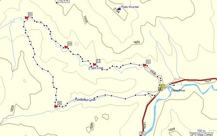
The route shown is three separate legs. The first 6 kilometres is the Prairie Creek Trail. The Trail continues on but at waypoint 5 is the intersection with the Prairie Link trail. This 3 kilometre section joins up with the Powderface Creek Trail for approximately 3 kilometres. The Powderface Creek trail ends about 200 metres west of the starting point for the Prairie Creek Trail. The total distance is 12.6 kilometres. The total climb is 300 metres so overall it is a pretty flat trail.
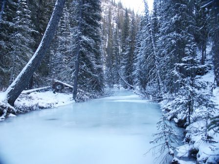
This photo was taken at the start, the creek is beautiful frozen or thawed.
This is the topographical map of this hike.
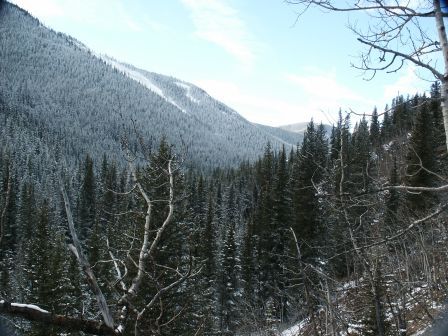
This photo was taken at waypoint 3 along the ridge above Prairie Creek.
On the day I did this hike it was slippery, like a skating rink. This is one of those trails that is cut into the side of the mountain. Anytime there is a thaw the water pools on the trail and freezes. At one point I slid off the trail for about 30 feet down onto the creek. Luckily it was frozen solid, otherwise I would have been wet. The GPS track is not available, it seems that when Garmin says that the batteries on the Etrex Legend will last up to 30 hours, greater emphasis should be put on the “up to” portion. In any event, just program in waypoints 5 and 6. Otherwise the trail is pretty easy to follow. Because of the way this trail drains I do not think I will go back until the spring. The position of these waypoints are as follows:
Waypoint #5 N50 53.125 W114 50.708
Waypoint #6 N50 51.714 W114 49.970
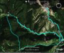
The Google Earth Map shows both the Prairie Creek and Prairie Mountain trail. I like this map, if you do both it allows you to have a better sense of your location and surroundings during the hike.
Please submit your feedback and let me know your thoughts on the hike. If you have the gps data for other hikes in Alberta please send it along with a couple pictures to hikealberta@gmail.com.

March 23, 2020 at 3:59 pm
[…] A week ago Saturday Yvonne and I went hiking on Prairie Trail and Powderface Trail at Elbow Falls. Apparently the section we hiked was about 12.6 km. The hike we did is in three sections. You can see more photos and a topographical map here: Hiking Alberta […]
September 12, 2022 at 4:48 pm
[…] A week ago Saturday Yvonne and I went hiking on Prairie Trail and Powderface Trail at Elbow Falls. Apparently the section we hiked was about 12.6 km. The hike we did is in three sections. You can see more photos and a topographical map here: Hiking Alberta […]